
A Very Strong El Niño Could Make for a Very Different Winter
Weather patterns across North America could look very different this year as a very strong El Niño continues to develop in the Pacific.
According to NOAA’s latest September update, there is now greater than a 90% chance of a very strong El Niño during the fall and winter of 2026–27. Sea-surface temperatures in parts of the eastern equatorial Pacific are already more than 3°C above average, and NOAA’s latest outlook gives a 75% chance that October through December will reach a historic El Niño strength threshold, exceeding the strength of previous events dating back to 1950.
So what does that mean? The answer is more complicated than simply “a warmer winter” or “a colder winter.” El Niño changes the position and strength of the jet stream, which can influence where storms track, where precipitation develops and where cold air settles across North America.
What El Niño Could Mean for the U.S.
El Niño begins thousands of miles away in the tropical Pacific, but its effects can extend across the continent.
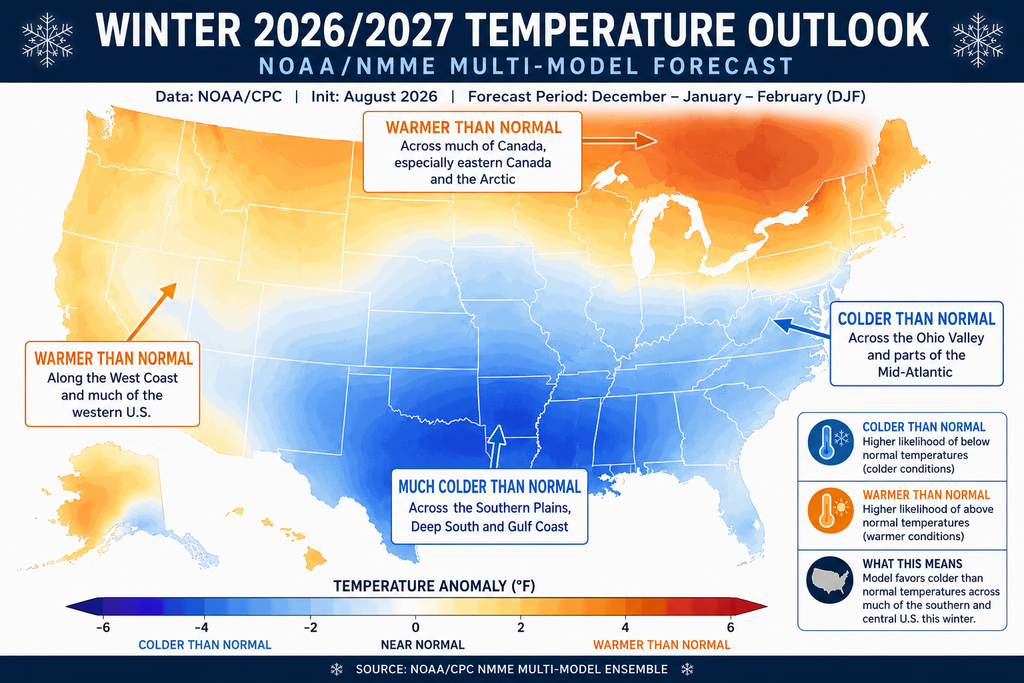
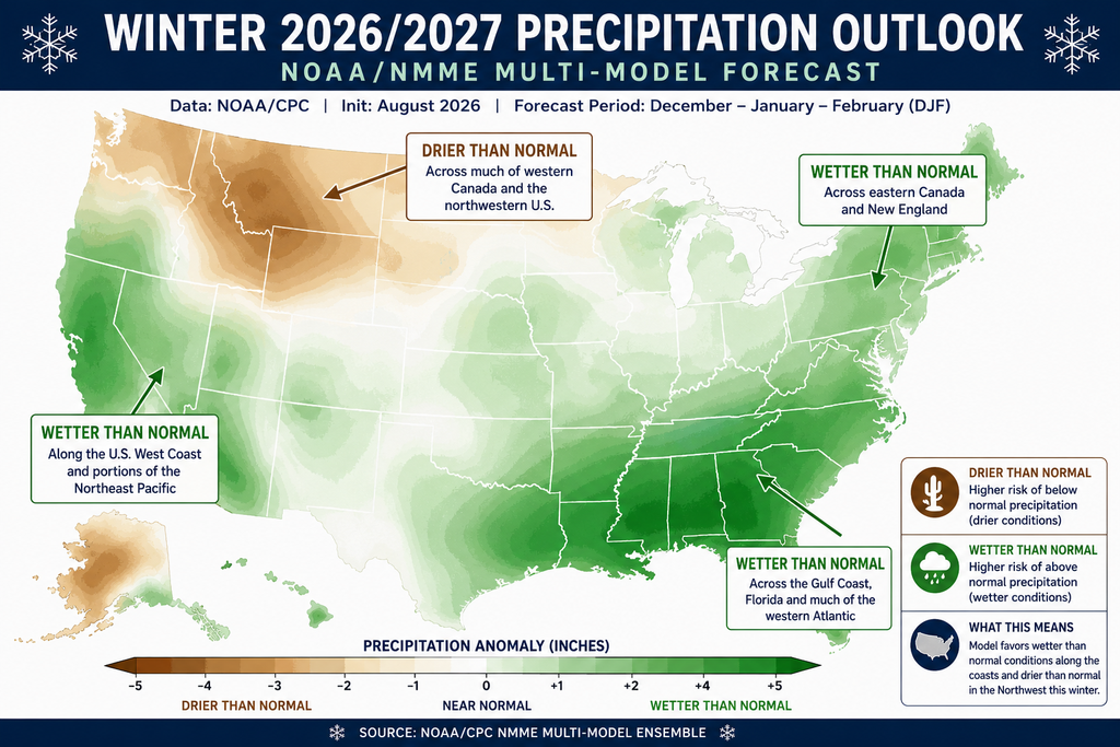
Historically, El Niño winters tend to favor wetter-than-average conditions across parts of the southern United States, while portions of the northern United States and Great Lakes can lean warmer and drier. The jet stream also tends to shift southward, changing the typical path of winter storms.
These are broad historical patterns and not a guarantee for what any particular city will experience. Weather can vary dramatically from one region to another, even during the same El Niño event.
And because this year’s event is expected to be unusually strong, meteorologists will be watching closely to see how closely the coming winter follows those typical patterns.
A Remarkably Quiet Atlantic Hurricane Season
One of the most interesting effects of a strong El Niño is what it can do to Atlantic hurricane activity.
El Niño typically increases upper-level winds over the tropical Atlantic, creating vertical wind shear that makes it more difficult for tropical systems to organize and strengthen. That is one reason strong El Niño events are generally associated with less Atlantic hurricane activity.
So far, 2026 is providing a striking example.
As of mid-September, the Atlantic hurricane season has produced six named storms but no hurricanes. Accumulated Cyclone Energy (ACE), a measure that accounts for the strength and duration of tropical systems, is also running far below the long-term average.
NOAA’s latest seasonal outlook calls for a below-normal Atlantic hurricane season, with 7–13 named storms, 2–6 hurricanes and 0–2 major hurricanes. NOAA specifically points to the strengthening El Niño and its associated wind shear as factors suppressing tropical activity.
But the hurricane season isn’t over. The Atlantic season officially continues through November 30, and even a below-normal season can still produce a storm capable of causing significant damage.
Could 2026 Become a Hurricane-Free Year?
It is too early to know, but the current lack of hurricanes is unusual enough to make the historical record interesting.
Since reliable Atlantic hurricane records began in 1851, only two seasons,1907 and 1914, recorded zero hurricanes.
That makes 1914 particularly interesting. Following that exceptionally quiet hurricane season, the eastern United States experienced a notably cold and stormy winter. Atlanta, for example, dropped to 11°F in December 1914.
That historical connection does not mean a quiet hurricane season causes a harsh winter, but it is an interesting reminder that large-scale atmospheric patterns can shift dramatically from one season to the next.
Another Factor to Watch: The Arctic
El Niño isn’t the only large-scale climate pattern worth watching this winter. Meteorologists are also keeping an eye on conditions in the Arctic and the behavior of the polar vortex.
The Arctic has warmed much faster than the global average, and sea ice has declined substantially over the past several decades. Changes in sea ice and Arctic temperatures can influence atmospheric circulation and the jet stream.
A disrupted or weakened polar vortex can sometimes allow Arctic air to push farther south, bringing periods of unusually cold weather to parts of the United States and Canada. However, these events are difficult to predict months in advance, so the current signals shouldn’t be interpreted as a guarantee of a major cold outbreak.
In other words, this winter could be particularly interesting because several large-scale atmospheric patterns are interacting at the same time.
What Does This Mean for Generators?
Whether the threat is a hurricane along the Gulf or Atlantic coasts, an ice storm in the Southeast, a winter storm across the Midwest, or extreme cold farther north, severe weather can put backup power systems to the test.
And that’s where generator monitoring becomes especially valuable.
A standby generator is only useful when it starts and operates when you need it. Remote generator monitoring gives dealers, facility managers and equipment owners visibility into the generator’s status without having to be physically standing next to it.
For facilities that depend on backup power, knowing that a generator is ready before severe weather arrives can make a significant difference.
Weather Is Difficult to Predict. Readiness Doesn’t Have to Be.
The biggest lesson from this year’s unusual El Niño setup is that weather patterns can change in ways that affect regions far beyond where the original conditions begin.
A strong El Niño is already helping suppress Atlantic hurricane activity, but its influence extends well beyond the tropics. It can also affect winter storm tracks, precipitation patterns and temperatures across the United States and Canada.
And while no seasonal forecast can tell us exactly what every community will experience, preparation can help reduce the risk when severe weather arrives.
For businesses and facilities that rely on standby generators, monitoring your backup power system year-round—not just when a storm is approaching—is one way to stay ahead of the unexpected.
The weather may be unpredictable. Your generator’s readiness shouldn’t be.